


AIS Flytomap GPS Chart Plotter
Description of AIS Flytomap GPS Chart Plotter
AIS Flytomap GPS Chart Plotter is a marine navigation application specifically designed for boaters and outdoor enthusiasts. This app offers real-time tracking and mapping capabilities, allowing users to monitor their vessels and nearby boats worldwide. Available for the Android platform, users can easily download AIS Flytomap to enhance their maritime experience.
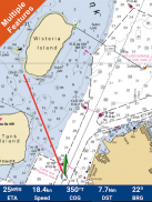
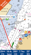
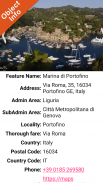
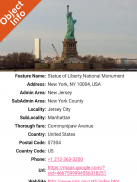
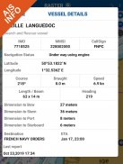
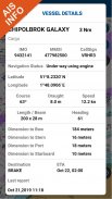
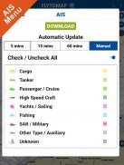
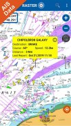
The app provides live AIS information without the need for an AIS receiver, ensuring that users can view their boat's position and that of other vessels in the vicinity directly on their mobile devices. Various icons represent different vessel categories, enabling quick identification of nearby boats. When selecting a target vessel, users can access detailed information, including the vessel's name, MMSI, IMO, call sign, status, speed, heading, coordinates, and distance from their current GPS location.
With AIS Flytomap, users have access to a professional GPS chart plotter through a subscription service, which is available for a nominal fee. This feature enhances the app's functionality, providing users with advanced navigation tools and marine charts. The app supports offline usage, allowing users to download maps directly to their device, ensuring accessibility even without an internet connection.
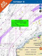
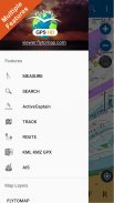
Users can explore various map types, including worldwide marine and outdoor maps, satellite images overlay, and terrain features, thanks to partnerships with Open Street Map, Open Cycle Map, and ESRI. NOAA raster charts are seamlessly integrated, providing continuous updates from official government sources. This ensures that users have the most accurate and up-to-date information for their navigational needs.
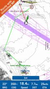
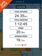
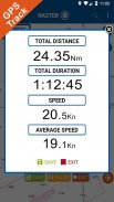
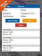
The navigation capabilities of AIS Flytomap are designed for ease of use. Users can input their desired destinations and see real-time updates on speed, distance, and bearing. The app includes a distance measurement tool to calculate distances between locations accurately. This feature is particularly useful for planning routes with multiple waypoints, as users can create routes that suit their specific navigation requirements.
Key features include a geocompass that assists users in orienting their navigation, as well as a head-up and course-up display mode that enhances situational awareness while navigating. The app also allows for background operation, enabling users to switch between AIS Flytomap and other applications while still receiving updates and notifications.
The app supports the sharing of unlimited tracks via email. Users can store their navigation tracks without needing cellular data or a mobile signal. This functionality is beneficial for users who wish to document their journeys or share their routes with others. Additionally, the app includes a KMZ/KML to GPX converter, which aids in transferring data between different navigation systems.
ActiveCaptain, a component of the app, connects users to a global community of boaters. This feature allows users to view and contribute information about marinas, anchorages, hazards, and local knowledge, creating a valuable resource for the boating community. With over 200,000 captains contributing to this platform, users can gain insights and recommendations based on firsthand experiences.
The app's interface is designed for intuitive navigation, allowing users to zoom, rotate, and pan maps with simple finger gestures. This user-friendly design makes it accessible for both seasoned sailors and those new to boating. Additionally, the app optimizes battery usage, ensuring that users can rely on their devices for extended periods while out on the water.
AIS Flytomap GPS Chart Plotter serves as a comprehensive tool for navigation and marine exploration. Its combination of real-time AIS tracking, offline map capabilities, and community-driven insights positions it as a vital resource for boaters seeking to enhance their maritime experience. With the ability to monitor vessel positions, access detailed charts, and contribute to a broader boating community, users are equipped with the necessary tools for safe and informed navigation.
By offering a range of features tailored to the needs of boaters and outdoor enthusiasts, AIS Flytomap stands out as a practical solution for marine navigation. The app's commitment to continuous updates and user engagement ensures that users can confidently navigate their favorite waterways while enjoying the benefits of advanced technology.
For more information, you can visit the Flytomap website at flytomap.com or explore the web app at viewer.flytomap.com. You can also follow Flytomap on Twitter and Facebook for updates and community engagement.
AIS Flytomap GPS Chart Plotter - Version 1.0.4.7.5
(18-11-2023)AIS Flytomap GPS Chart Plotter - APK Information
APK Version: 1.0.4.7.5Package: com.flytomap.marineapp.worldviewer.aisflytomapLatest Version of AIS Flytomap GPS Chart Plotter
Other versions


Apps in the same category


